
Masai Mara’s map is typically depicted as an irregular polygon that reflects its diverse and dynamic landscape. The reserve’s boundaries are not defined by straight lines but by a series of natural features that give it a fluid, almost organic shape. For example:


- Mara River Boundary: The southern edge of the reserve is largely defined by the meandering Mara River. Its winding course creates a curved, sinuous boundary that resembles a natural, flowing line rather than a rigid border.
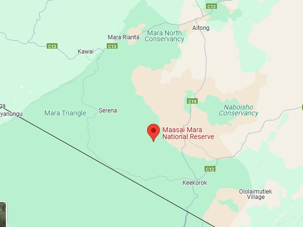
- Mara Triangle: Within the reserve, the Mara Triangle stands out as a distinctly triangular section. This area is renowned for its high densities of predators and wildlife and is demarcated by more clearly defined natural borders, setting it apart from the more sprawling areas of the reserve.
- Eastern and Northern Limits: These areas often blend into the surrounding savannah and pastoral lands, where administrative boundaries mark the limits. The transition is gradual, with open grasslands and scattered woodlands that contribute to the reserve’s expansive feel.
- Western Escarpments: The presence of rugged terrain and steep escarpments on the western side adds an additional layer of irregularity, with elevated outcrops and valleys that punctuate the otherwise rolling plains.
Academic research and expert analyses highlight that this irregular, almost patchwork-like shape is not merely a cartographic curiosity—it plays a crucial role in the ecology of the area. The varied topography creates natural corridors and isolated pockets, influencing wildlife movement, predator-prey dynamics, and even the distribution of vegetation. In essence, the map of Masai Mara is a visual representation of the complex interplay between geology, hydrology, and biology, making it one of Africa’s most fascinating and ecologically significant landscapes.
Map of Masai Mara Conserancies
The Masai Mara National Reserve is surrounded by 24 conservancies located to the north and east of the Reserve. Below are maps highlighting the conservancies in the northern, central, and eastern regions of the Mara. These maps were sourced from the official Masai Mara Wildlife Conservancies Association Interactive Map. You can check the original map on MMWCA’s webpage here.


Masai Mara Interactive Map
Guide to the Masai Mara Map: Answering Your Questions
The Masai Mara map is much more than a simple geographic outline—it’s a dynamic representation of one of Africa’s most intricate ecosystems, and understanding it can enrich your safari experience, research, or conservation efforts. Here’s an in-depth guide addressing all common questions related to the Masai Mara map as an entity:
- What Does the Map Show?
The Masai Mara map details the boundaries of the Masai Mara National Reserve and its sub-entities, such as the Mara Triangle and various conservancies. It displays natural features—such as the winding Mara River, riverine forests, open grasslands, and rugged western escarpments—that collectively define the region’s unique ecology. The map also includes man-made elements like road networks, visitor centers, and designated campsites, all of which help in planning safari routes and conservation activities. - How Are the Boundaries Defined?
Unlike maps with neat, straight borders, the boundaries of the Masai Mara are largely dictated by natural features. The Mara River, for instance, forms a significant part of the southern edge with its meandering course, while the eastern and northern limits blend into surrounding pastoral and agricultural lands. The Mara Triangle, a distinctly triangular section within the reserve, is demarcated by both natural markers and administrative lines, ensuring focused conservation and controlled tourism in that area. - What Is the Mara Triangle?
The Mara Triangle is a specific section of the Masai Mara known for its high wildlife density and lower human interference. Expert studies, such as those featured in the African Journal of Ecology, highlight its importance for predator-prey interactions and conservation research. The Mara Triangle map emphasizes key features like waterholes, migration corridors, and areas of concentrated wildlife activity, making it a prime area for both safari operators and researchers. - What Topographical and Hydrological Features Are Illustrated?
The map illustrates the reserve’s undulating grasslands, characterized by gentle rises and dips that influence water drainage and vegetation patterns. Major rivers—the Mara, Talek, and Sand—are prominently shown, highlighting their role as lifelines that shape wildlife migration and distribution. The western escarpments, including notable features like the Olololo Escarpment, add an extra dimension by providing elevated viewpoints and influencing microclimates within the reserve. - How Do Conservancy Maps Fit In?
In addition to the official Masai Mara National Reserve maps, there are detailed maps for various conservancies (e.g., Olare Motorogi, Naboisho, Mara North, Oloololo) that outline privately or community-managed areas. These maps display smaller, well-defined boundaries, wildlife corridors, and infrastructural details such as ranger posts and eco-friendly lodges. They are critical tools for decentralized wildlife management and for promoting sustainable tourism. - How Do I Read and Interpret These Maps?
Key elements to look for include the legend (which explains symbols and color codes), scale (to understand distances), and topographical lines (which indicate elevation changes). Pay attention to natural markers like rivers and escarpments, as these often determine animal movement and key safari routes. GIS overlays and satellite imagery integrated into modern maps offer updated information on vegetation cover and seasonal changes. - Why Are These Maps Important for Safari and Conservation?
For safari operators, these maps are indispensable for planning routes that maximize wildlife sightings while minimizing environmental impact. Conservationists rely on these maps to monitor land use changes, habitat fragmentation, and migration patterns, ensuring that protection strategies remain effective. Academic and field research often uses these maps as baselines to track ecological changes over time. - Frequently Asked Questions
- Can I use the map to plan my own safari?
Yes, detailed maps are available that can help you chart your own course, whether you’re a seasoned traveler or a first-time visitor. - How often are the maps updated?
Many modern maps integrate GIS and satellite data, ensuring that changes in vegetation, water levels, and human developments are reflected as frequently as possible. - Are there digital versions available?
Absolutely; both official reserve websites and various conservation organizations offer downloadable and interactive maps.
- Can I use the map to plan my own safari?
In summary, the Masai Mara map encapsulates a complex interplay of natural and human-made elements, revealing the region’s diverse ecosystems, critical wildlife corridors, and areas of conservation priority. Whether you’re planning a safari, conducting research, or simply curious about one of Africa’s most iconic landscapes, understanding the Masai Mara map opens a window into the rich tapestry of this extraordinary region